We had a very busy and successful first day of Cay Sal Bank coral reef research today, completing 6 separate dives in the vicinity of Anguilla Cay. The groundtruthing team, comprised of Dr. Sam Purkis and Jeremy Kerr, set off mid-morning in their catamaran and covered roughly 30 nautical miles surveying the seascape with a depth sounder and a drop camera. Near the end of the day, Sam and Jeremy dropped in for one dive near the southern end of the bank. You can see their track below as yellow dots covering the length of Anguilla Cay.

The coral and fish teams completed two dives in the morning on the windward side of Anguilla Cay, and one dive in the afternoon near the Shadow on the leeward side via the M/Y Golden Osprey. The consensus from the fish surveying team was that the area has a high diversity of fish species, including surgeonfish, angelfish, and at least one African Pompano. They also noted the large abundance of macro algae.
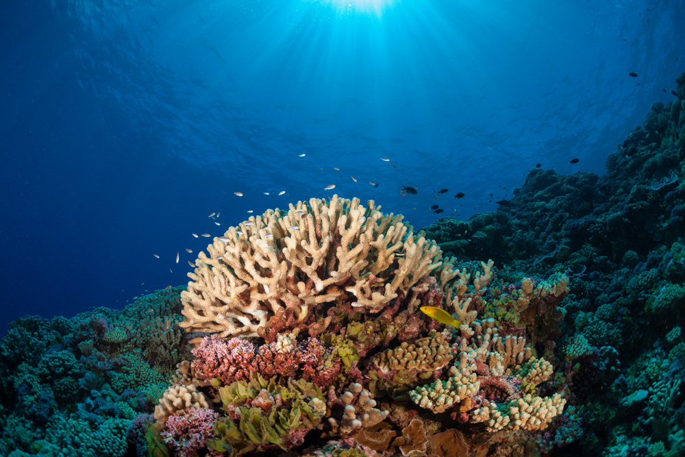
The coral reef transect teams reported few corals, but healthy ones. Dr. Andy Bruckner noted a couple of small coral “recruits” – the starts of new corals – but the overwhelming majority of the corals appeared to be older. Coral reef expert Judy Lang explains that some of the corals appear to be small remnants of what may have been a much larger colony several years ago. As part of the Atlantic and Gulf Rapid Reef Assessment (AGRRA) program, her team is determining the percent of partial mortality of the corals by evaluating how large a coral may have been in the past and then estimating what percentage is left now to determine current health and resiliency.

Living Oceans Fellow Sonia Bejarano scoped out a spot for her first camera placement, and strategically set down 10 GoPro underwater cameras. Later in the day, Sonia and Executive Director Phil Renaud returned in a small RHIB to the experiment site and collected the cameras. Each one recorded approximately 3 hours of footage for a total of 30 hours of survey footage. Sonia is hoping to collect imagery of herbivorous fishes (the vegetarians of the fish world) feeding without human disturbance.
Last, but not least, a small team set out in the late afternoon to deploy the Acoustic Doppler Current Profiler (ADCP) device near the northern point of Anguilla Cay. The ADCP will measure temperature, oxygen levels, conductivity and turbidity at the seafloor. Phil Renaud explains that it is important to monitor these four physical attributes of the area because they affect our understanding of the resiliency of the corals. A site with at least a moderate current will continually flush the area and keep the corals in cooler water as ocean temperatures rise, allowing them to stay healthy.

The deployment of the ADCP made for an exciting final dive of the day not only because it is the first time the Living Oceans Foundation has had a chance to use this hi-tech sensor, but also because the strong currents in the area made it quite difficult for our team to get the device set properly on the seafloor. DSO Tim Payne, Chief Scientist Andy Bruckner, and NCRI researcher Bernard Reigl did an incredible job getting the device in the water, weighing it down and keeping an eye on it until GIS Analyst Amanda Williams was able to take several GPS coordinates of the site. The ADCP will sit on the seafloor taking measurements over the next few days and the team will retrieve it before we set sail for our next anchorage, where it will be deployed again.
Post by Liz Smith
Don’t forget to follow along on Facebook to get blog updates and see more photos! You can also follow the expedition on our Global Reef Expedition main page, where there is more information about our research and our team members.
(Image credit: 1. Amanda Williams; 2, 3. Leno Davis; 4, Liz Smith)