After 22 dives in 8 days, we are finished surveying in the beautiful Vava’u island group. This afternoon, we are traveling 15 hours to get to our final island group, called the Niuas. It’s the northernmost group of islands consisting of three islands: Niuafoʻou, Niuatoputapu, and Tafahi. It’s so far north that we will actually be closer to Samoa than any of the other island group in Tonga.
The Niuas: Unique and Untouched Volcanic Islands of Tonga
This island group is unlike the rest. The Niuas are the least developed island group and there are only around 1,600 people living there. The Tongans practice the traditional ways of life. Even the dialect here is different. It’s actually closer to the Samoan dialect.
Niuatoputapu meaning ‘sacred island’ has the highest population in the Niuas. The island is the remnant volcano that last erupted around 3 million years ago with its highest elevation reaching only 157 meters in height. On September 30, 2009, an earthquake with a magnitude of 8.3 caused a tsunami to hit Niuatoputapu killing 9 people and destroying the coastal villages 500 meters inland.

Niuatoputapu, the most populated of the Niuas. This is the end of the island where the tsunami first hit. Most of the trees were removed by the storm.
Tafahi has a population of around 34 people. The island is smaller than Niuatoputapu; however it has a much higher elevation of 560 meters or (1,860 feet). The island is volcanic and therefore the soil is very fertile. Vanilla and kava are primarily exported and the main livelihood here.

Tafahi Island is volcanic in nature and it has the highest elevation in the Niuas.
The northernmost island, Niuafoʻou, is a volcanic rimmed island with its greatest elevation being 260 meters in height. The island encompasses two crater lakes. This volcano has been the most active of the three islands erupting in 1853, 1912, 1929, 1935, 1936, 1943, and 1946. In 1946, the residents had to be removed from the island due to the violent eruption. They were not allowed to return to the island until 1958.
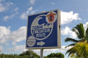
Tsunami evacuation route sign on Niuatoputapu
We are excited to go to this remote and virtually untouched island group.
Photos by: 1-3 Amy Heemsoth

